In Action


This is an exceptional piece of gear, it fits my needs better than any other navigator I have used. I recently had the opportunity to use it on my kayak sailboat navigating and camping in the Ten Thousand Islands out of Naples, FL.
The good:
It is crystal clear in low light and direct sun. The images are crisp, with fine detail. The maps are beautiful and surprisingly detailed, and the screen size makes all this detail actually useful. The search function works amazingly well, there was nothing I asked for that the device could not locate.
Navigating was a pure pleasure. I mostly used point-to-waypoint but I also had a chance to create and follow routes. For this function the device is far superior (smarter) compared to my Garmin 86sci. And the touch screen makes selecting a waypoint so much easier than the Garmin. And as far as visibility, well, the two devices just don’t compare. Other than that the Maptattoo has all the functions that I need, with the exception of a couple of nit picky items that are just personal preferences.
I love the ability to superimpose current data on the map, this is so much easier than toggling between map and data views. That said I actually would prefer to have the data displayed until I want to hide it, but the device turns the data off after a minute or so (is that to save power?). It is easy enough to call it back up, but I really like having it displayed longer on the map. Everything I need is there for tracking progress and estimating arrival, it calculates everything in a useful and intuitive way. But is there any way to show estimated arrival TOD at destination? Oh, and can it switch from 24 hour to 12 hour clock? While we are on the display, the only suggestion I have is to make the track line bolder/easier to see. It is OK, but bolder would be better for me for both the navigating line and the track. Also, while the course deviation (shown in degrees on the info display) is really helpful I would personally also like to have velocity made good as an option, but no big deal.
All in all I could not be happier. This device is an uncompromising improvement and it has added significantly to my enjoyment of small boat navigation, thanks!


My boat has no way other than a small solar panel to charge the boat battery this ruled out a chart plotter like Raymarine. Maptattoo with its built in battery and 6" screen I feel that I have found a good fit. Now I am looking for a mount that will secure it so that it won't fall over board. The many lines and shifting side to side while tacking are my concern. A flush mount and a tiller extension my resolve this concern. Returning this spring I will use the training and be familiar with Maptattoo, I can have a less stressful adventure.
Sailing the Georgian bay and the North Channel. See you out there.

Walt


I have not used it on the boat due to weather but have set it up in my home as well as in a vehicle. All simulations seem flawless and accurate. I am very impressed with the battery life which seems to never run out. I have used it several hours at a time which is as long or longer than any race and the battery shows no usage. I would guess that the advertised life of 50 hours is right on or not far off. I have never had a battery last this long in such a small package.
I also like the idea that It can be mounted most anywhere with various mounts either purchased on the Maptatoo site or from outside sources. The Maptatoo company has been very helpful in suggesting other effective ways of mounting that does not need to be purchased from the company.
I would gladly purchase again. If on the fence, do yourself and favor and find the unbiased articles on its' actual use.


Would like to see... 1) Option to change the scale of the boat-arrow, soundings and buoys independently, and 2) Note buoys by their color/number and not by name (e.g. "R 5" vs "Hopkinton Shoals Buoy").
Would definitely recommend this product.

Hoping to see updated Small Craft Routes on Georgian Bay (AquaMaps?) available for next season as this area is not supported yet. Customer support has been excellent, all questions have been answered clearly and promptly.
Overall, I am very pleased with the unit.


I will be completely honest, I kept it in a soft, waterproof tablet case the whole time. It's not a reflection of the waterproofed quality of the device, but more a reflection that I don't trust any device to hold up to such prolonged wetness.
In the position it was in it was regularly under breaking waves, and I just wanted extra protection.
The battery this device has is phenomenal. I didn't have it powered on the whole time, but would power it on from time to time to check my location and my speed. Sometimes I would keep it on for hours at a time just so I could see my speed.
I did have a few instances where the screen would freeze when booting up, or the whole device would suddenly freeze up. In all instances I just turned the device off and on again to resolve.
I realized at one point that when trying to charge it from a battery pack with a USB-C connection that the battery pack was actually charging from the MapTattoo. I changed cords to a Type A to C style and was able to resolve. That's not really a mark against the device, but perhaps worth bearing in mind.
I wish it was possible to forgo the touch screen completely while still being able to access the tide and current information.
The details of the chart are a little imprecise when compared to the larger scale paper charts. As a kayaker I'd love for more information about the aggregate of the intertidal.
Overall it's a really good device. Perhaps not perfect for kayakers but a heck of a lot better than the other alternatives I've tried.

The first outing was a kayak tour to test basic functionality. It handled waypoints beautifully—automatically switching to the next waypoint when crossing the 90-degree threshold from the previous one. Very intuitive. Biggest takeaway from that trip: I missed the feedback from the device after switching to a different kayak.
Second trial was on a DIAM 24 in wet, spray-filled conditions. The standout feature here was the VMG (Velocity Made Good) calculation. On a boat that sails wide angles, it was incredibly useful to visualize the trade-off between speed and distance—really helped with tactical decision-making.
Feature request:
When actively sailing to a waypoint, the map view becomes less helpful since it’s often not within easy view of the helmsman. It would be great be able to switch to a simplified display option showing just the essentials:
• Speed
• Heading
• Distance to Target
• VMG
• Target Heading
• Degrees to Target
Basically, just the first two rows of data in a clear, compact view taking up the whole screen.
Overall: I love this device and would absolutely buy it again. Great tool.


I bought your unit because we now cruise about in boats 20’ and under, the 50-hour battery life is fantastic, the traditional-looking chart format feels like home to me, growing up continuously using charts, and my old school navigation background to get about. The screen can be seen in any light. Just great. Your unit is easy to use, I like the large numbers for speed because in a small vessel going 5 knts +- it’s nice to be able to use to see current changes quickly in passages up here. Being outside in the rain, being able to have your unit as my helper in navigation with no worries of battery time, wet chart or guide book, seeing real-time position and speed is the next level up of today's navigation tool.


In preparation I’ve used it several times kayaking on San Francisco Bay. It’s highly readable sitting on my sprayskirt in bright sun and even in rougher conditions it didn’t seem affected by waves washing over. I really like the “fast forward” feature to quickly understand how the current is affecting my route. The black and white screen is generally ok - though it’s hard to see shipping lane boundaries. I wish there was a way to “bump up” the visibility of those.
I haven’t had a chance to download a route yet - and I found adding waypoints on the fly a bit exasperating. They get automatically “named” and the names sometimes don’t make a lot of sense. It would be nice if you were able to call up a master list of waypoints and be able to edit the names.


In The Press
“
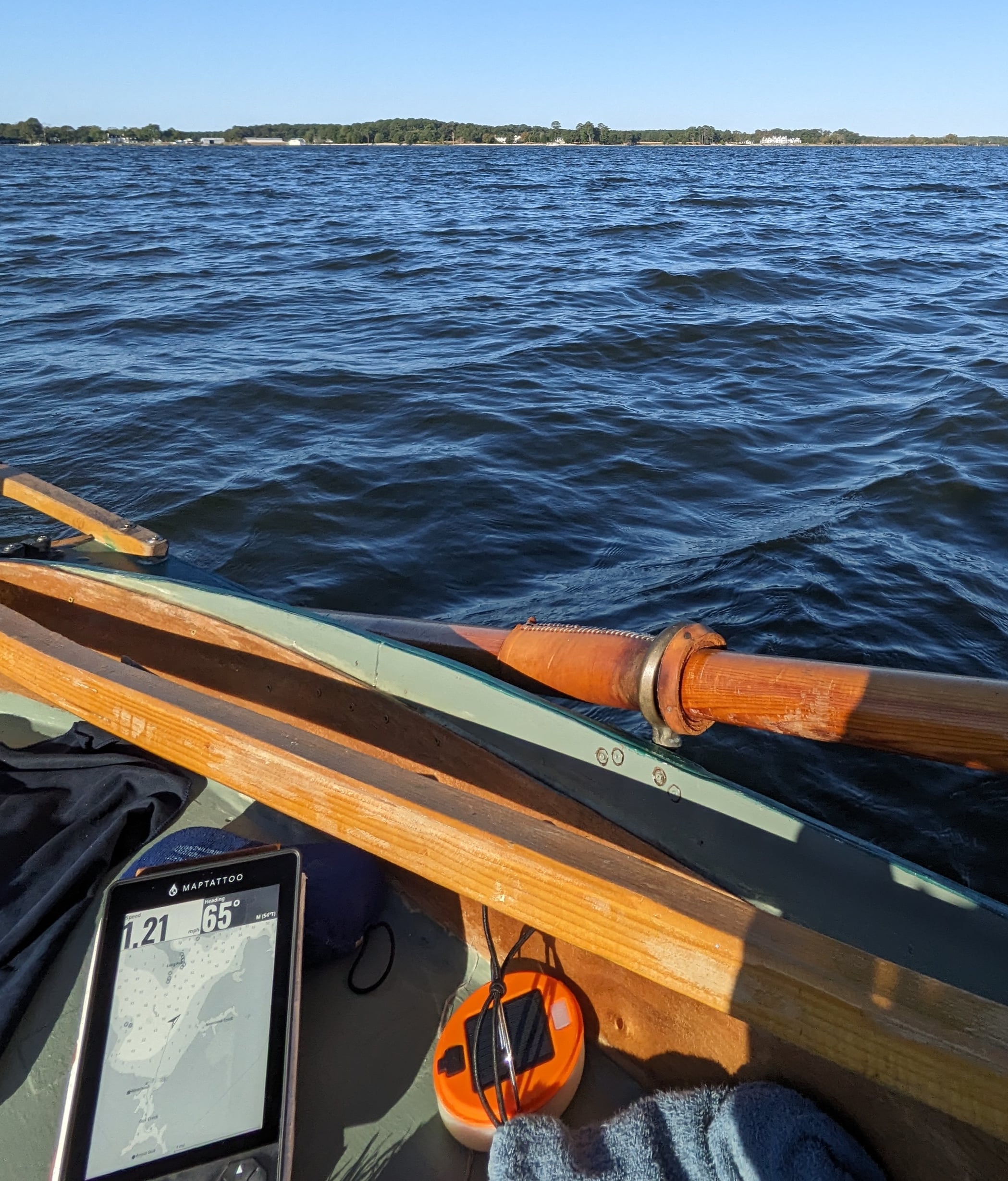
“The display can be read in any light from bright sunlight to night darkness. The speed and heading are presented in large numbers that can be read from a distance, and the device can be operated via the control buttons beneath the display, or with touch-screen commands.
This is a product for the demanding. Seeing Henry Worsley come up when I turn it on is a reminder that navigation is serious and MAPTATTOO is, indeed, meeting the needs of the serious user.” – Ben Fuller at Small Boats Magazine Read More


“
“The MAPTATTOO tablet chartplotter addresses a number of the items on my wish list. The 6-inch display is much bigger than anything I’ve got now, but it’s not too big to use on my smaller boats. It has a touchscreen that’s backed up by a keypad. It will run 50 hours on its internal battery and doesn’t require a power cord “leash.”
The MAPTATTOO power consumption is so frugal, only 400 mW (or an order of magnitude less than the Garmin 44dv), that I could probably leave my power station at home. I’m looking forward to seeing how well it performs during the next Everglades Challenge, Seventy48, and R2AK.” – Jerry Culik at Small Craft Advisor Read More

Trusted by Explorers
From races (R2AK, Everglades Challenge, Worrell 1000) to cruises, MAPTATTOO is trusted by athletes and explorers alike

Worrell 1000 with MM Sailing
In the world of competitive sailing, where precision and teamwork are paramount, MM Sailing truly stands out. Founded by two F18 champions with rich backgrounds in boat design and competitive racing, the team has carved a name for itself on the global stage.
One of the key tools in MM Sailing’s arsenal is MAPTATTOO. “It has always been amazing, but the battery life and readability during both day and night have been ideal. There’s nothing more terrifying than losing your electronics at night when you’re sailing between sandbars and breakers. I also have to say that MAPTATTOO isn’t just a tablet—it’s a team of people who love what they do and really care about their community.”

In-depth Review by Morley Elridge
“I‘ve wanted for a long time to write a review of this new small-boat navigation device. MAPTATTOO may be assembled in Chicago, but it was born on the BC Coast, during the inventor/adventure racer Erwan Kerebel’s rowing/sailing Race to Alaska.
He used a phone running Navionics to go from Port Townsend to Ketchikan. He got there in the end, but on the way had a life lesson in the shortcomings of using a phone to navigate. Short battery life with painful and frequent recharging; hard to see in sunlight or in the dark; hard to read from more than elbow length away; and trying to pinch and scroll and select on a touch screen with cold wet hands and flying spray… MAPTATTOO fixes all that.”

Daring Adventures with Ryan Finn
From making history as the first to sail the fabled “route d’Or” in a roa to his triumphant finish at the Everglades Challenge, ‘24 Ryan Finn’s journey is nothing less than remarkable.
A lifelong sailor, Ryan’s time on the water began with family cruises along the Gulf Coast, but it was an interest in keel boat racing later on that truly ignited his love for sailing. His passion for the sport was solidified in 1994, when he watched Isabelle Autissier compete in the BOC solo around-the-world race, setting the course for his sailing future…

Exploring Maine with Mark Sperry
Living in Coastal Maine, Mark found himself in a moment of spontaneity during the pandemic. “Someone listed their O’Day Daysailer for a cheap price.”, he recalls. “I bought the boat on impulse, and pretty much from there, I became obsessed.”
Mark now sails a Tanzer 22, a slightly larger keel boat, with MAPTATTOO on board: “When I was using my iPhone, you would be pulling it out of your pocket, watching the battery drain, losing focus on your environment. The MAPTATTOO is there for at-a-glance situational awareness which is the most important thing in a place like Maine. Our underwater rocks are sneaky. Please don’t ask me how I know!”


